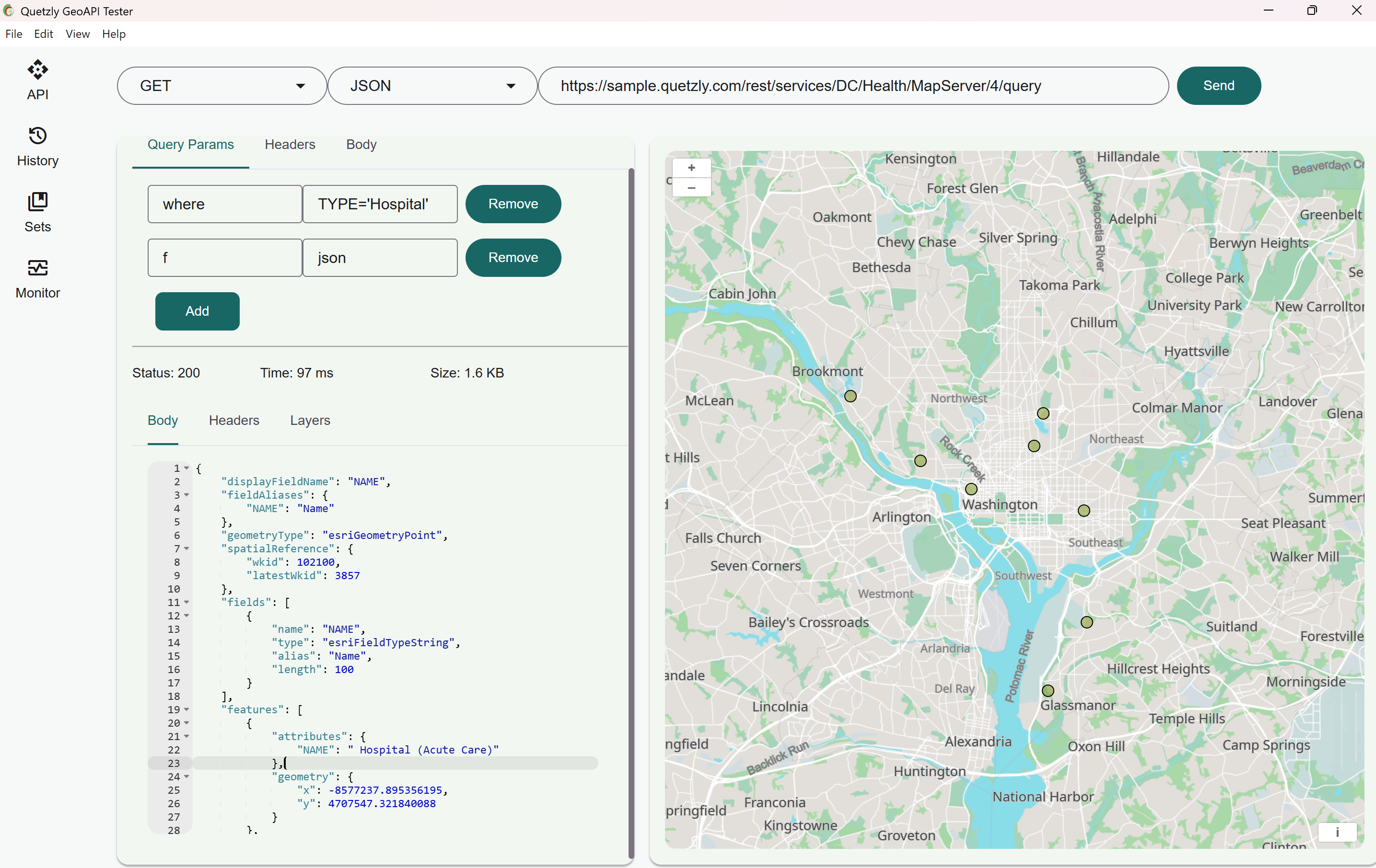
Quetzly is a specialized professional GeoAPI testing tool designed specifically for developers and technical teams who work with geospatial data services and map APIs. The tool provides comprehensive capabilities for testing, monitoring, and visualizing geospatial APIs across various platforms and standards, including ArcGIS, OGC WMS/WFS, and GeoJSON endpoints. Its primary purpose is to ensure the reliability and performance of mapping services by offering developers a streamlined way to validate endpoints, identify issues, and maintain service health without requiring complex enterprise solutions or extensive custom scripting. The platform serves as an essential utility for organizations that depend on geospatial data delivery, helping technical teams maintain service quality and prevent disruptions to end-users who rely on accurate map data for their applications and workflows.
Developers working with geospatial APIs frequently face significant challenges when services fail or underperform, often discovering problems only after frustrated users or stakeholders report issues. The traditional approach to monitoring these services typically involves either implementing complex enterprise monitoring systems like ArcGIS Monitor, which requires substantial setup time and budget, or developing custom Python scripts that demand ongoing maintenance and technical expertise. Both approaches create operational overhead and delay problem detection, potentially allowing broken map layers or slow services to impact end-users before technical teams become aware of the issues. This reactive troubleshooting model forces developers to spend valuable time investigating problems after they've already affected users, rather than proactively preventing service disruptions through systematic monitoring and testing.
The platform's core testing functionality enables developers to validate geospatial endpoints comprehensively, checking for proper responses, correct data formats, and expected performance characteristics. When testing services, Quetzly automatically scans endpoints in the background, continuously checking for errors and performance issues without requiring manual intervention from development teams. This automated scanning approach catches problems before they impact end-users, allowing technical teams to address issues proactively rather than reacting to user complaints. The system supports multiple geospatial standards including ArcGIS services, OGC WMS/WFS protocols, and GeoJSON endpoints, ensuring broad compatibility with the most commonly used geospatial data formats and service architectures in modern mapping applications.
admin
Interactive map visualization represents another major feature group, providing developers with immediate visual feedback about their geospatial services' performance and data quality. Unlike traditional API testing tools that only provide textual or numerical results, Quetzly displays service responses directly on interactive maps, allowing developers to see exactly how their data renders and identify visual anomalies that might not be apparent in raw data responses. This visualization capability helps teams quickly spot issues like incorrect layer rendering, missing tiles, coordinate system problems, or styling inconsistencies that could affect user experience. The visual approach transforms abstract technical data into concrete, understandable representations that make troubleshooting more intuitive and efficient for development teams.
Endpoint monitoring capabilities provide continuous oversight of geospatial services, tracking availability, response times, and data integrity over extended periods. The monitoring system runs regular checks against configured endpoints, maintaining historical data about service performance and generating alerts when services deviate from expected behavior. This continuous monitoring approach helps teams establish baseline performance metrics, identify trends in service degradation, and predict potential failures before they become critical issues. The system's monitoring functionality operates independently of application usage, meaning it can detect problems even when services aren't being actively accessed by end-users, providing comprehensive coverage that traditional user-facing monitoring might miss.
The technical approach combines automated background scanning with browser-based troubleshooting tools, creating a comprehensive solution that addresses both proactive monitoring and reactive problem-solving needs. Services are scanned continuously in the background, with results presented through a visual dashboard that provides immediate status overviews and detailed error information. When issues are detected, developers can use integrated browser tools to investigate problems directly within their development environment, eliminating the need for separate debugging scripts or complex development tools. This integrated approach reduces the technical barrier to effective geospatial service monitoring while maintaining the depth of analysis needed for professional API management and quality assurance.
Users benefit from measurable outcomes including reduced troubleshooting time, improved service reliability, and enhanced communication with stakeholders about service health. Development teams can transition from spending hours investigating reported issues to addressing problems proactively before they affect users, significantly reducing the mean time to resolution for geospatial service problems. The professional reporting capabilities allow teams to document service conditions and uptime statistics, providing concrete evidence of service reliability to stakeholders and clients. These benefits translate into tangible business value through reduced support costs, improved user satisfaction, and better resource allocation for development teams who can focus on feature development rather than emergency troubleshooting.
Concrete use cases include weekly service health checks where development teams run comprehensive scans of all geospatial endpoints to generate reliability reports for management and clients. Another specific workflow involves setting up continuous monitoring for critical production services, with automated alerts configured to notify developers immediately when response times exceed thresholds or error rates increase. Development teams can also use the tool during the deployment process for new geospatial services, running validation tests to ensure endpoints are functioning correctly before making them available to users. Integration testing represents another common use case, where teams verify that their applications correctly interact with geospatial services and that data flows properly between systems.
The target users include developers, GIS specialists, and technical teams working with geospatial data across industries like mapping applications, location-based services, urban planning, environmental monitoring, and logistics. The tool integrates with existing development workflows through browser extensions and supports the technical stacks commonly used in geospatial development, including various mapping libraries and API frameworks. While specific pricing plans aren't detailed in the provided content, the platform positions itself as a lightweight alternative to enterprise solutions, suggesting accessibility for teams of different sizes and budgets who need professional geospatial testing capabilities without the complexity and cost of traditional enterprise monitoring systems.
Quetzly fundamentally transforms how development teams manage geospatial services by providing comprehensive testing, monitoring, and visualization tools in an accessible package that doesn't require enterprise-level investment or extensive custom development. The platform's combination of automated background scanning, visual troubleshooting, and professional reporting creates a complete solution for maintaining geospatial service quality, enabling teams to catch problems before users notice them and communicate service reliability effectively to stakeholders. By addressing the specific challenges of geospatial API management with targeted features and an intuitive interface, the tool helps organizations ensure their mapping services remain reliable, performant, and valuable to end-users across various applications and use cases.
Quetzly targets developers, GIS specialists, and technical teams working with geospatial data across various industries including mapping applications, location-based services, urban planning, environmental monitoring, and logistics. These users need to ensure the reliability and performance of their geospatial APIs but want to avoid the complexity and cost of enterprise monitoring solutions like ArcGIS Monitor. The tool serves organizations that depend on accurate map data delivery and need to maintain service quality without extensive custom scripting or months of setup time. It's designed for technical professionals who work with ArcGIS, OGC WMS/WFS, and GeoJSON endpoints and require efficient ways to test, monitor, and visualize their geospatial services.
Updated 2026-02-28